Route C – Audlem to Crewe (25 miles-easy / moderate)
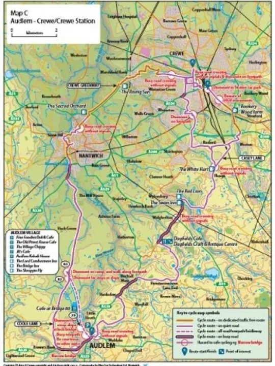
The options for reaching Crewe from Audlem divide into an east route (C1) and a west route (C2) which has a greater proportion of traffic free cycling, and the option to shorten the journey using the canal towpath, when conditions permit.
East Route (C1) – (24.7 miles-easy)
The east route splits north of Hough, to offer alternative routes for Crewe town and Crewe station. This route follows back roads and 'B roads' with some traffic-free cycleways on the approach to Crewe Station.
- The crossing of the A525 at the end of School Lane requires care.
- A short (0.8) mile section of the busy A529 is involved from Hankelow northwards. Alternatively, this section has a good footway which can be walked with cycles, but cycling on it is not permitted.
- Care is required on the several crossing points of main roads and on the final approaches to Crewe and Crewe Station. The approach to Crewe station on the feeder road parallel to Weston Road has many HGV movements and great care should be taken in this area.
- The traffic free cycle ways should be used on the sections marked rather than the roads.
- Casey Lane between Hough and Weston Lane can be busy with commuting motorists at weekday rush hours. The alternative via Basford is recommended at these times.
- The Crewe town route requires cyclists to dismount and walk their cycles over a 20-metre section of footpath to the north of the railway bridge, where cycling is not permitted.
- The town route includes a short section of the A534 Nantwich Road which has cycle paths marked on the carriageway which should be used.
- Please note that cycle racks are located in the east station car park, but that cycling in the car park is not permitted, so cyclists should walk their cycles through the car park to the racks.
West Route (C2) – (25 miles-easy / moderate)
This option follows our suggested cycle routes to just before Nantwich, after which we join the Crewe Greenway which offers fast comfortable cycling with a high proportion of traffic free cycle paths. It is a most pleasant way to travel to Crewe.
The route to Nantwich utilises the rural back road Coole Lane with a half mile section of the A530 leading towards Nantwich centre via traffic-free cycle paths.
The exit from Audlem is achieved either by:
Route C2 – (26.3 miles-easy)
By road via Whitchurch Road to Coole Lane
- Avoiding the towpath section, this route involves a 1 mile section of the A525 Whitchurch Road to Coole Lane.
- This is a busy main road requiring caution, especially around the narrow bridge crossing the River Weaver.
- There are short sections of moderate gradient either side of the bridge over the Weaver, but otherwise the route is largely flat.
Route C2* – (24 miles-moderate)
The canal towpath from Audlem Wharf to Coole Lane.
- Approximately half of the towpath section is on hard surface, with the remainder on compacted earth which can be muddy and slippery after rain. Not recommended in wet or icy winter conditions.
- Access at the Audlem end is flat, but at Coole Lane there are two options:
{either a short but very steep flight of steps to link directly at the road bridge 82. Cyclists must be confident that they can carry their cycle up or down these steps before attempting this option. Dismounting essential.
or a ramp at Bridge 83, from where a short footpath links with Coole Lane. Cyclists must dismount and walk the short ramp and footpath section as cycling is not permitted. The towpath section between bridges 82 and 83 can, however, be muddy and slippery after rain.}
- The towpath can be busy with walkers and anglers at weekends. Please be courteous and follow the towpath code. Watch out for anglers, use your bell well ahead and be prepared to dismount.
- The towpath route option is generally flat with no steep gradients, other than one very short steep lock approach at Bridge 79, where dismounting between the lock and the bridge is recommended.
In the Riverside Park on the approach to Nantwich, the route skirts around the town centre to join the Crewe Greenway.
- Where cycle paths are indicated, they should be used.
- Care should be taken on the major road crossing points, including the Stewart Street crossing in Crewe and at the Wistaston Green Road crossing near the Rising Sun pub. Care should also be taken on the approaches to Crewe and particularly the busy Edleston Road.
- The cycle way includes a pleasant section through the middle of Queen's Park. When the park is not open, an alternative route around the park perimeter is shown.
- If travelling to Crewe Station, care should be taken crossing Edleston Road and Mill Street. Dismounting is required for a short footway section east of Mill Street where cycling is not permitted.
- Cycle racks are available in the short-term car park to the west of the station. Cycling is not permitted in the car park.
Refreshments
East route (C1):
The Boars Head, Walgherton
The Red Lion, Wybunbury
The Swan Inn, Wybunbury
The White Hart, Hough
West Route (C2):
The Sacred Orchard, Nantwich
Alveston Hall Hotel
The Rising Sun, Marshfield Bank